The Hyperion Stockpile Monitoring System delivers next-generation precision and automation for 3D point clouds. Especially designed for operations handling bulk materials across mining, construction, and industrial environments, Hyperion provides fast, accurate, and reliable volumetric data eliminating guesswork and boosting operational efficiency.
Hyperion is a modular system powered by proprietary software that delivers highly accurate volume calculations from 3D point clouds.
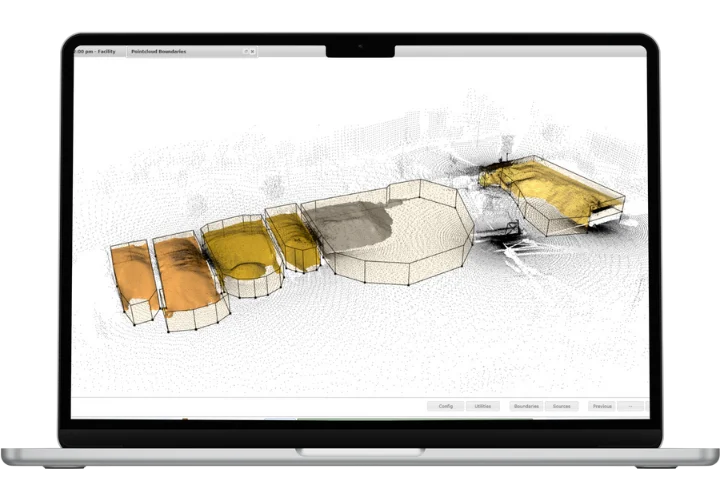
It seamlessly accepts manual data inputs from external sources, such as processed drone flights or other point cloud-generating sensors. However, Hyperion performs at its best when paired with our EOS2 sensor. Our advanced surface-generation algorithm processes the scans and calculates precise volumes within minutes.
Fast and Reliable stockpile inventory measurment solution.
Easily generate point clouds using the EOS2 sensor—or import data manually from drones or third-party scanners for full flexibility.
Pointclouds are automatically processed using our advanced surface generation algorithm. Volumes and 3D models are created and quality-checked in minutes.
Results are pushed to your visual dashboard or exported via API. Enables instant decision-making and accurate reconciliation.
Experience unmatched speed and accuracy in bulk inventory measurement. Whether you manage a single stockpile or a complex facility, Hyperion adapts to your scale and workflow. Contact us today to schedule a consultation.
Built-in proprietary quality assurance shows where data is missing and has been interpolated, discarding or flagging periods of questionable accuracy.
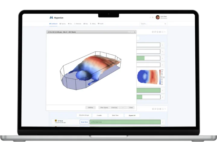
Intuitive dashboard for real-time monitoring and historical data analysis. Easily access scan reports, 3D models, and volume trends.
Seamlessly integrate multiple sensors or data sources for larger areas. Scalable coverage for expanding stockpile operations.
When using the EOS2 sensor you can schedule scans on demand or at set intervals. Integrate with existing inventory systems or ERP platforms.
Compatible with common geospatial file formats and external data sources, making it easy to integrate with your existing workflows or drone systems.
Assign roles and permissions for different team members, ensuring secure access to sensitive project data and analytics.

Watch how Hyperion delivers fast, accurate, and automated volumetric measurement using advanced LiDAR technology. In just minutes, generate precise 3D pointclouds, visualize real-time inventory data, and make smarter operational decisions—without manual effort.
Get the answers you need and start optimizing your operations with Hyperion.
Hyperion uses proprietary surface generation algorithms to deliver sub-meter accuracy. Each scan is processed and quality-assured to ensure reliable volumetric results.
Scans can be triggered on demand or scheduled at regular intervals hourly, daily, or custom-set depending on your operational needs. This flexibility ensures you always have up-to-date inventory data.
Yes. Hyperion is a modular system, meaning you can deploy multiple sensors across your facility. The data is automatically merged and registered to create a seamless view of your entire stockpile.
Absolutely. Hyperion provides API access and exportable data formats to integrate smoothly with most inventory management, ERP, and reporting platforms.
Do not hesitate to reach out. Just fill in the contact form here and we’ll be sure to reply as fast as possible.
info@altamusinc.com
+1 352-283-8003